xearth tropical storm overlay
Two new things for xearth this week. First, there is a new overlay for current tropical storm activity. The source data is the Tropical Storms, Worldwide data set from the University of Hawaii. I wrote a script to download the current tropical storm file (which is a flat ASCII file), some Python code to convert that to an SVG file, and then converted that to a transparent PNG for the overlay.
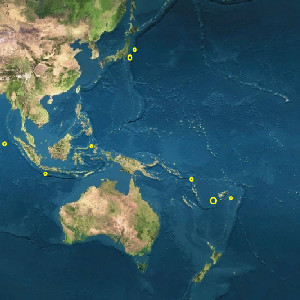
The other new thing is xearth now supports multiple overlay files. Here's an example showing all map and overlay features (the Living Earth base map, and earthquakes, storms, and clouds overlays).
I'm going to improve the presentation of the tropical storm map so the labels are more visible, especially when combined with the cloud overlay (white on white is not an ideal colour combination).
Greg Hewgill <greg@hewgill.com>
The other new thing is xearth now supports multiple overlay files. Here's an example showing all map and overlay features (the Living Earth base map, and earthquakes, storms, and clouds overlays).

I'm going to improve the presentation of the tropical storm map so the labels are more visible, especially when combined with the cloud overlay (white on white is not an ideal colour combination).